

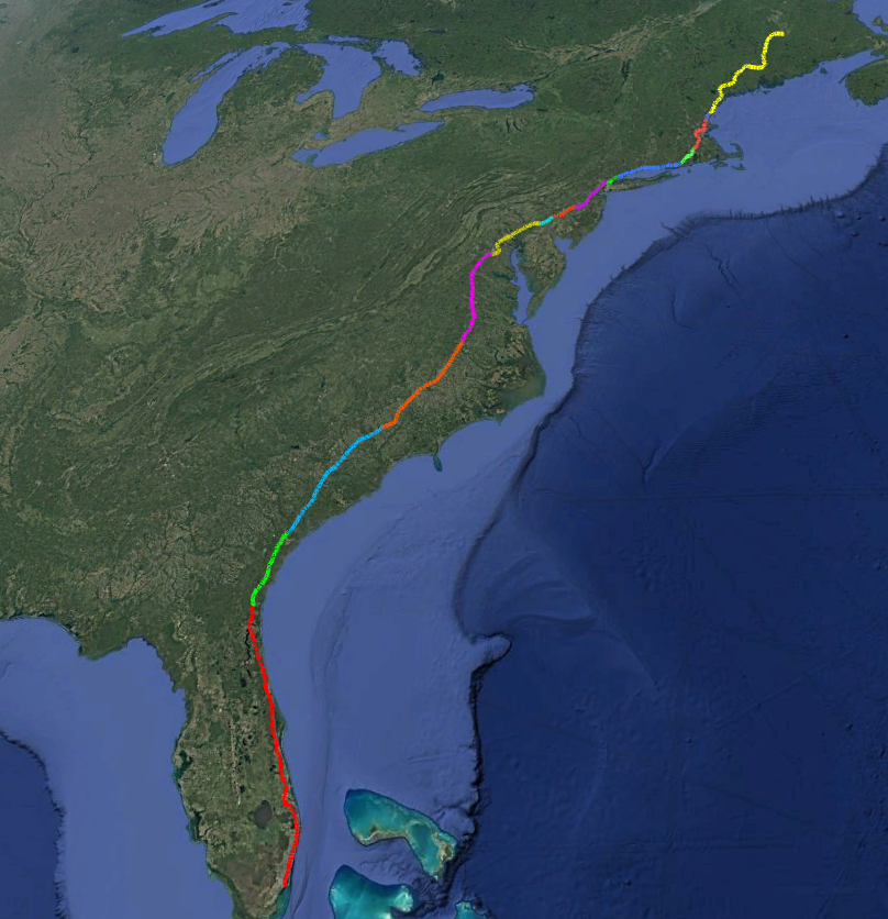
15 states. One vehicle. A continuous, dual-direction point cloud record of America’s most critical highway corridor, captured at highway speed.
Why I-95?
Interstate 95 is more than a highway. It’s the connective tissue of the American East Coast, a 1,920-mile corridor running from the northern tip of Maine to the southern edge of Miami, threading through some of the most densely populated, economically productive, and infrastructure-critical terrain in the world.
The corridor passes through 15 states and the District of Columbia, links major metropolitan centers from Boston to Miami, supports an estimated $800 billion in annual freight movement, and connects nearly 110 million people, roughly one-third of the U.S. population.
For all that importance, comprehensive geospatial data along I-95 has been sorely lacking. Departments of Transportation, utility operators, telecom providers, and broadband planners have historically relied on fragmented datasets, outdated aerial imagery, or expensive ad-hoc surveys to plan and maintain infrastructure along the corridor. Teleqo Tech set out to change that, producing the dataset the corridor has needed for decades: a single, continuous, end-to-end point cloud record covering every mile from Maine to Florida.
A corridor that spans 15 operating environments
The I-95 corridor runs through Maine, New Hampshire, Massachusetts, Rhode Island, Connecticut, New York, New Jersey, Pennsylvania, Delaware, Maryland, Virginia, North Carolina, South Carolina, Georgia, and Florida.
Each state presents a distinct operational environment, with dense mixed-use corridors and aging infrastructure in the Northeast, some of the most congested urban highway segments in the country through New York and New Jersey, mid-Atlantic transitions between metropolitan hubs and suburban expansion zones, and rapidly growing communities, coastal lowlands, and high-demand broadband and utility build zones from the Carolinas south.
Each state also brings its own regulatory environment, infrastructure age profile, and data needs, which is precisely why a complete, consistent, end-to-end dataset has such significant value. A single corridor survey, captured to a uniform spec, eliminates the patchwork that has historically made multi-state planning so difficult.
The platform: a Riegl VMY-2 built for highway-scale work
Teleqo Tech collected the I-95 corridor using a purpose-built mobile LiDAR survey vehicle equipped with the Riegl VMY-2, one of the most capable mobile LiDAR sensors available for highway-scale data collection.
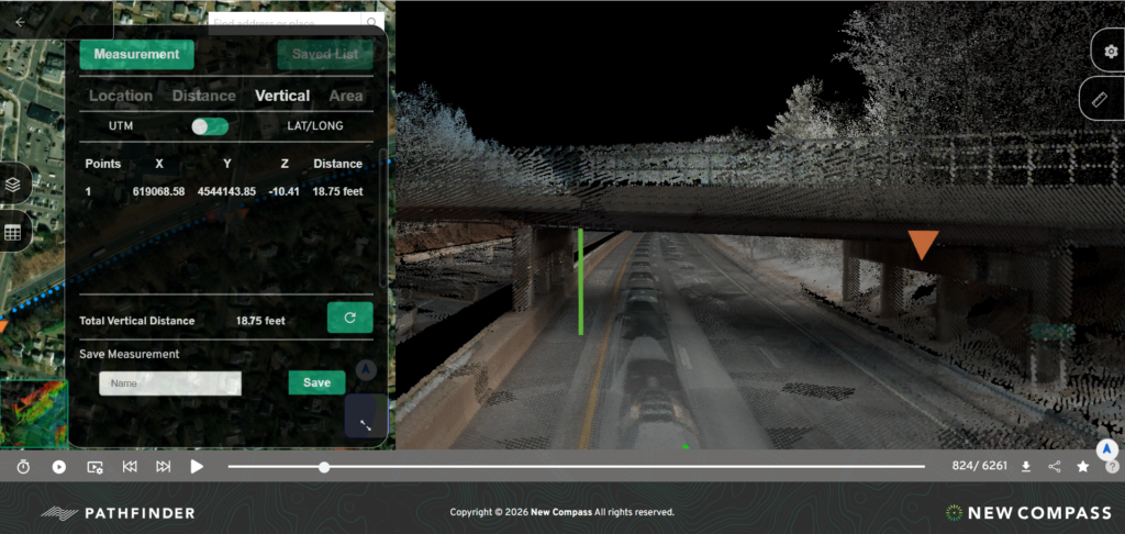
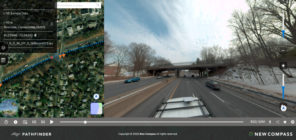
The VMY-2 is a dual-head LiDAR system designed specifically for high-speed mobile scanning, delivering exceptional point cloud density, precision, and range at highway travel speeds. This LIDAR sensor is integrated with a Ladybug6 camera, which produces 72 MP panoramic imagery.
The VMY-2 and Ladybug6 produce beautiful imagery paired with a rich, fully georeferenced 3D point cloud with centimeter-level accuracy, capable of capturing everything from pavement texture and roadway markings to utility poles, overhead lines, signage, vegetation, drainage structures, and building façades, all in a single continuous pass.
The system integrates tightly with high-accuracy IMU/GNSS positioning to maintain spatial precision even in challenging signal environments like overpasses, tunnels, and urban canyons.
Dual-pass collection: why we drive every mile twice
To maximize data quality and ensure full coverage redundancy, Teleqo Tech conducted dual-direction collection along the corridor, capturing every segment in both the northbound and southbound directions. This approach is more work, but it delivers four advantages that single-pass collection can’t match:
- Complete bilateral coverage. Assets on both sides of the roadway are captured at optimal scan angles from each direction of travel, eliminating the occlusions inherent in single-direction collection.
- Redundant verification. Double-pass data allows for cross-validation of asset positions and attributes, improving both the accuracy and the confidence level of the resulting dataset.
- Comprehensive vertical infrastructure capture. Utility poles, sign structures, and overhead attachments are scanned from multiple vantage points, ensuring that hardware on all faces of a structure is represented in the point cloud.
- Improved density in complex environments. In areas with heavy overhead canopy, complex interchange geometry, or high roadside infrastructure density, dual-pass collection significantly improves point cloud completeness.
The result is a 1,920-mile dataset of exceptional depth and reliability: a continuous, dual-direction point cloud record of the entire I-95 corridor from Maine to Florida.
From collection to delivery
A point cloud, no matter how rich, is only as valuable as the tools that make it accessible. That’s where Teleqo’s affiliated software company, New Compass Solutions, comes in.
The corridor dataset is delivered through New Compass’s Pathfinder visualization platform, which lets users virtually drive the corridor in an interactive 3D environment, and the Ranger extraction engine, which turns the raw point cloud into structured, queryable asset records (utility poles, overhead lines, signs, guardrail, vegetation, and pavement features) at corridor scale.
The collection-to-delivery handoff is what makes the dataset usable on day one. Teleqo Tech owns the field execution and the quality of the capture; New Compass owns the platform layer that turns 1,920 miles of point cloud into something a make-ready engineer, a DOT asset manager, or a broadband planner can sit down and query.
What the corridor unlocks
For state DOTs, the dataset supports MUTCD sign audits, guardrail and pavement programs, clear-zone analysis, and HD-mapping baselines that would cost tens of millions of dollars to replicate through conventional survey.
For telecom providers and state broadband offices working on BEAD-funded fiber deployment, it supports desktop make-ready engineering across hundreds of miles of corridor without the time and cost of traditional field surveys.
For electric, gas, and water utilities, it supports remote inspection, vegetation-risk management, and joint-use documentation across vast service territories, all with an objective, third-party-validated record of existing infrastructure conditions.
A purpose-built corridor record
The Teleqo Tech I-95 corridor dataset isn’t an academic exercise. It’s a purpose-built, operationally oriented resource designed to support the infrastructure decisions that will define the eastern seaboard’s transportation, energy, and communications networks for decades to come.
From broadband engineers conducting make-ready analysis in rural Virginia to DOT planners managing sign upgrade programs in Massachusetts to utility operators assessing pole conditions in Georgia, the data delivers immediate, tangible value at every point along the corridor.
With 1,920 miles of dual-pass Riegl VMY-2 data captured by Teleqo Tech and delivered through New Compass’s Pathfinder and Ranger platforms, we’re offering something that has never existed before: a complete, consistent, and immediately actionable geospatial record of the full I-95 corridor, ready to go to work.
For licensing inquiries or to schedule a demonstration of the I-95 corridor dataset
Contact Teleqo Tech at info@teleqotech.com.